The majority of wildfire activity continues in the southern half of B.C., with eight fires of note burning in the Kamloops and southeast regions.
As of Monday (Aug. 8), there are 61 active fires in B.C., 21 of which are in the Kamloops area and 18 of which are in the southeast. Another seven are burning in the Prince George area, and five are burning in each of the coastal, northwest and Cariboo regions.
The majority (41 fires) continue to be caused by lightning, with another seven attributed to humans and 13 unknown. Of them, 19 are under control, 17 are being held, 13 are out of control, eight are fires of note and four are new. Fires of note are ones that are considered particularly threatening or visible.
There have been 551 wildfires recorded since the start of this year’s season. That is about a fifth of the activity B.C. normally experiences at this point in the summer, according to BC Wildfire Service. Still, the fires have burned thousands of hectares of land and forced hundreds of residents under evacuation alert or order.
These are the eight wildfires of note:
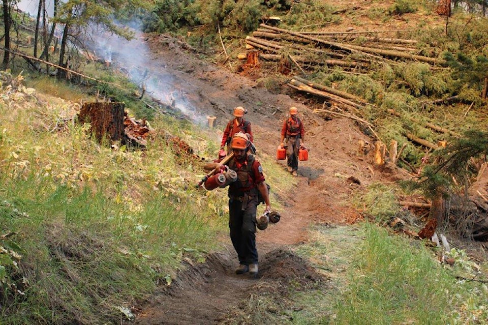
Keremeos Creek
Estimated fire size: 5,903 hectares
Location: 21 kilometres southwest of Penticton
Discovered: July 29
Cause: Under investigation
Conditions on the Penticton-area blaze were favourable overnight Sunday, with crews spending their time monitoring the most threatening areas and putting out hot spots.
On Monday, crews plan to continue with small planned ignitions on about 30 hectares of ground north of the town of Olalla. Increased smoke and flames may be visible to people in Olalla and Keremeos during the work.
Hand ignitions will also be used on the northeastern corner of the fire, from the end of Sheep Creek Road north.
In other areas, crews continue to create contingency lines and install sprinkler systems to protect properties.
The Olalla Creek Forest Service Road is closed. Evacuation orders and alerts remain in place.
A total of 405 firefighters are fighting the blaze, with the assistance of 16 helicopters and 45 pieces of heavy equipment.
UPDATE: This afternoon, #BCWildfire completed planned ignitions in multiple locations on the Keremeos Creek wildfire (K50863). Crews successfully brought the fires edge from difficult to access terrain down to workable control lines. pic.twitter.com/aOlRfuvdhh
— BC Wildfire Service (@BCGovFireInfo) August 8, 2022
Crew operations are one of the largest parts of the firefighting effort. In this video, a #BCWildfire Service squad boss explains a day in the life of a unit crew on the Keremeos Creek wildfire (K50863). pic.twitter.com/KQzXedNw9i
— BC Wildfire Service (@BCGovFireInfo) August 8, 2022
Maria Creek
Estimated fire size: 1,004 hectares
Location: 6 kilometres northeast of Pavilion
Discovered: July 31
Cause: Lightning
The wildfire hasn’t seen any growth outside existing perimeters since Aug. 3, but continues to be worked on closely by crews. They’ve used heavy equipment to gain access to the fire and are now building containment lines by connecting roads and cut blocks.
Ground crews are laying down hose around the perimeter.
Ninety-eight firefighters are on scene, along with two helicopters and 18 pieces of heavy equipment.
Nohomin Creek
Estimated fire size: 3,745 hectares
Location: 1.7 kilometres northwest of Lytton
Discovered: July 14
Cause: Suspected human
Evacuation orders for the area have been rescinded, but fire activity continues in the Stein Valley Nlaka’pamux Heritage Park. Here, BC Wildfire says steep cliffs and rocky terrain have made it extremely difficult for crews to battle the blaze.
The fire’s south, northeast and east flanks remain stable.
It’s being co-managed by Lytton First Nation and BC Parks, with BC Wildfire Service providing support as needed.
Watching Creek
Estimated fire size: 270 hectares
Location: 16 kilometres northwest of Kamloops
Discovered: July 29
Cause: Suspected lightning
The wildfire hasn’t seen any significant growth since Aug. 2, but incoming warm and dry conditions could increase fire activity.
Crews are continuing to fight the fire’s edges with water and by breaking down burning materials with hand tools. Helicopters are also onsite and bucketing water over the flames.
There is no current threat to any structures, according to BC Wildfire. Still, evacuation alerts remain in place and the Pass Lake recreation site is closed. Watching Creek Campground is also closed.
There are 78 firefighters on scene, along with six helicopters and two pieces of heavy equipment.
Briggs Creek
Estimated fire size: 1,679 hectares
Location: 11.5 kilometres west of Kaslo
Discovered: Aug. 1
Cause: Lightning
The fire hasn’t seen significant growth since Aug. 6 and continues to burn within containment lines.
As of Sunday, it is moving slow and keeping low to the ground in most areas, but BC Wildfire says incoming hot and dry conditions could cause an increase in intensity.
It is very visible to people in Kaslo, and may appear closer than it is to the town during evening hours.
No evacuation orders or alerts are in place, but BC Wildfire has issued an area restriction for the region.
There are 14 firefighters and one helicopter on scene.
Connell Ridge
Estimated fire size: 1,350 hectares
Location: 23 kilometres south of Cranbrook
Discovered: Aug. 1
Cause: Lightning
The fire continues to actively burn within the established perimeter, but hasn’t grown in size for several days. BC Wildfire says this could change this week as temperatures increase, however.
An evacuation alert is in effect for six properties in the area, as is an area restriction.
There are 67 firefighters on scene, along with nine helicopters and 27 pieces of heavy equipment.
The Connell Ridge (N10989) wildfire is being actively supported by 27 pieces of heavy equipment from numerous industry partners. Heavy equipment and their operators are a vital part of wildfire operations and work closely on the fire line with #BCWildfire personnel. #Cranbrook pic.twitter.com/alP32YtN6Z
— BC Wildfire Service (@BCGovFireInfo) August 8, 2022
Cummings Creek
Estimated fire size: 43 hectares
Location: 5 kilometres west of Sparwood
Discovered: Aug. 3
Cause: Lightning
Crews saw aggressive fire activity on the eastern flank overnight Sunday, where the wildfire continues to burn in steep, inoperable terrain. The difficult landscape and resulting smoke have made it largely unsafe for ground or air crews to work, according to BC Wildfire.
Residents of Sparwood will likely see an influx of firefighting equipment Monday, as structure protection personnel begin assessing properties in the area. BC Wildfire says this is being done proactively, and that Sparwood is not under immediate threat.
Weasel Creek
Estimated fire size: 482 hectares
Location: 2 kilometres west of Frozen Lake and 39 kilometres southeast of Baynes Lake
Discovered: Aug. 4
Cause: Lightning
The fire was initially discovered in the United States on July 30 and spread into the Flathead Valley in Canada on Aug. 4. About 482 of the fire’s total 965 hectares are burning on B.C.’s side of the border, according to BC Wildfire.
A structure protection specialist is assessing the area and determining if any resources are needed.